General Chat / Google Earth
-
 09-July 05
-

 ECC
Offline
http://earth.google.com/
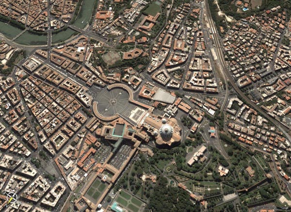
How to make google maps even better. You can look at the entire world with a bunch of extra features like 3d buildings!
(Major cities only, no surprise there)
Rome
Grand Canyon
Eiffel Tower
Hoover Dam
http://earth.google.com/ -

 Steve
Offline
That is some cool shit.
It'd be cool if the buildings had some details on them though. -

 Jellybones
Offline
Is this the program formerly known as Keyhole?
At any rate, I'm downloading it, though I have a sneaking suspicion that there's NO WAY IN HELL my computer will be able to run it. -

 Jellybones
Offline
Okay, so much to my surprise, it works (though not in DirectX mode, only in OpenGL mode. That means nothing to me except that my computer probably isn't very good). The 3d buildings and shit don't really thrill me, but looking at ski areas and other such mountainous areas is great fun. Not a lot are covered since not a lot of rural areas are covered. But all of Massachusetts is covered, so Wachusett and other MA mountains are there. And Killington is the only thing covered in Vermont seemingly, and it's amazing to check out a place that big in this program.
Another thing, when it flies from one location to another...holy crap. That is so trippy. I love it. -

 GigaForce
Offline
Man this thing is so much fun. I wish there were 3D buildings in Major cities around the world, not just the US.
 -

 Jellybones
Offline
Okay. This is now a "show off cool things you've found in Google Earth" thread.
here are my initial contributions.
Part of the massive Killington resort in Vermont. L to R at the top: Superstar area, Killington Peak, and Snowden Peak. At the bottom on the left is the Snowshed area, with a tiny piece of the base of Rams' Head Peak on the right.
The view from the top of the K1 Gondola at Killington Peak.
Mt. Wachusett, in central Massachusetts. With some snow on the trails, even! What's really cool is how similar this shot is to this Wachusett aerial photo.
The view from the summit of Wachusett.
 Tags
Tags
- No Tags

